Screening System for Soil Contamination Risk (Simplified Land-use History Assessment)
Drops in the value of real-estate collateral due to soil contamination have become a subject of considerable concern among financial institutions. Surveying for soil-contamination risk includes simple surveys like those conducted in Phase 1 as well as the more detailed surveys of Phase 2 and Phase 3. However, in terms of costs none of these surveys is practical for application to massive holdings of collateral properties. For this reason, it is more efficient to conduct screening at a preliminary stage prior to introducing such detailed surveys. Also, in light of practical lending operations there is a need to assess collateral value through estimating the volume of soil-contamination risk at the screening stage as well.
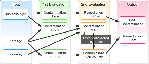
As screening for collateral properties and other properties, we assess the risk of soil contamination on subject properties. Based on the business site’s address, lot number, and acreage data, we assess the site’s soil-contamination risk by reviewing historical land-use data such as residential land maps. This service, which can provide quick surveys while keeping the surveying cost per property down, provides an optimal range of consulting services to clients who hold numerous properties that are subject to surveying. It also can assess the total volume of soil-contamination risk involved in the properties pledged as collateral to banks.
Services
Service Highlights
- Assessment can be conducted using only objective, easily obtainable information such as address and acreage (without relying on self-declaration by the land owner).
- Provides superior objectivity and accountability since risk volumes are estimated using past performance data and clear estimation logic.
- Remediation costs reflect the latest actual performance data, making it possible to estimate the most up-to-date remediation costs.
- Services also include assessment of neighboring properties, to assess contamination suffered from other areas of contamination.
- We use a massive database on land-use history, groundwater, and other information, particularly putting to use data on land-use history accumulated in our own insurance business.
- Elimination of unnecessary survey steps such as accumulation of unneeded land-use history data makes it possible to reduce survey costs.
- In light of the highly confidential nature of information on financing, risks of data leaks can be avoided through conducting inspection and analysis tasks in locations having assured security levels.
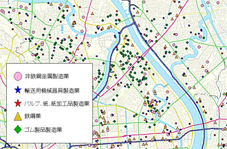 Land-use Information around 1970
Solution Concepts
- Use of easily available information such as address and acreage makes it possible:
-
- To estimate decreases in value due to soil contamination, which should be reflected in the real-estate prices of individual properties pledged as collateral
- To ascertain the total volume of soil-contamination risk faced by a financial institution
Contact
Please send an e-mail to
Please call to
+81-3-5288-7426
(Real Estate Risk Solution)